Did China ram a Philippine Vessel?
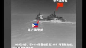
China’s Coast Guard said a Philippine vessel that had ignored its repeated warnings “deliberately collided” with a Chinese Coast Guard vessel in an “unprofessional and dangerous” manner in the Sabina Shoal waters, (part of the Philippines’ exclusive economic zone) in the Spratly Islands, around 19:24 GMT on Sunday, 18 August 2024.
It appears that the Chinese Coast Guard vessel had been trying to keep the Philippine Coast Guard vessel out of that part of the Philippines’ exclusive economic zone.
The Philippine Coast Guard [PCG] said their vessels, the Cape Engano and Bagacay, were on their way to resupply personnel stationed on Flat Island when the collision took place. The Bagacay was rammed twice by a Chinese coastguard vessel.
This clip from the Chinese video appears to show the Chinese vessel ramming into the Philippine vessel.

Sabina Shoal is 123.6 nautical miles from Palawan Island. It is located in the West Philippine Sea and is part of the Philippines’ exclusive economic zone.
Philippine sovereignty in the natural resources-rich area is now under threat from China, which continues to ignore the 2016 international arbitral ruling that recognized Philippine ownership of WPS.
Where are the Spratly islands?
The Velarde map was published in 1734, showing the Spratly islands and the Scarborough shoal as part of the Philippines territory.
The Velarde map, along with 270 other maps, was used to refute China’s historic claim of ownership of the sea area around the Philippines.
In 2016 the Permanent Court of Arbitration in The Hague ruled that China had “no historical rights” based on their nine-dash line map.
What is the Chinese nine-dash line map?
The Chinese nine-dash line map, is a Chinese claim that overlaps with the exclusive economic zones of Brunei, Indonesia, Malaysia, the Philippines, Taiwan, and Vietnam.
Philippines Exclusive Economic Zone.
This image shows the Philippines Exclusive Economic Zone, which includes the Spratly Islands, and it’s location in the West Philippine Sea.

What is an Exclusive Economic Zone?
An Exclusive Economic Zone (EEZ), stretches 200 nautical miles from the coast of the state in question.
The EEZ gives the country exclusive rights for fishing, drilling, and other economic activities in its area.
Sea Distance Conversations.
200 nautical miles = 370 kilometres.
119 nautical miles = 220 kilometres.
594 nautical miles = 1,100 kilometres.
119.1 - 959,835